Page, AZ to Grand Canyon
Trip Distance: 140 miles
Total Distance: 4,775
Our Route:
We left out of Page, AZ on Thursday morning, heading south on hwy. 89. We traveled thru cities with names like Tuba City and Cameron. We turned onto hwy. 64 and headed toward the east entrance to the Grand Canyon. We weren't sure if the RV and towed car would be able to pull thru some of the scenic spots on the rim, so we drove straight to the Grand Canyon Trailer Village to settle in and meet up with Jessica and Ali.
They had driven out from California on Tuesday and we waiting on us to join them.
As soon as we got the RV unpacked, we met Ali and Jessica. We decided to ride the blue shuttle to the Visitor's Center. We watched the movie there and Adam picked up another Jr. Ranger Program booklet.
We then changed buses for the orange line following Ali's directions. The bus system at Grand Canyon was a bit intimidating, but once we got the hang of it, it was time to leave.
Anyway, we got off at Yaki Point and took in our first real views of the South Rim.
Words can not express....

The Rose kids.

We took the rim trail at Pipe Creek Vista and walked back to the Visitor's Center and Mather Point.
A distant view of the switch backs on the South Kaibab Trail.

The Rose clan.
"My group, this way!"
which were the words we would say when it was time to get off the shuttle bus. It was hard to keep all of us together.

Nana and Paw.


All of these buttes and points have names, but I can't remember any of them.
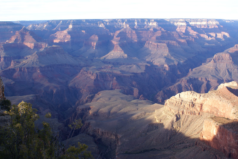

We ended the day eating back at the RV and hearing of Jessica's adventures around the world.
Adam spent the night with Ali and Jessica in their tent in the Mather Campground, where the temperatures dropped down to 32. It was cold.
Day 37:
Hike the South Kaibab Trail.
We started out Friday morning as a group, hiking the South Kaibab Trail. It starts out with a series of 4 or 5 switchbacks and descends rapidly.


You can see what a view there is.

When we got to Ooh Aah Point, Nana, Paw and Adam went back up the trail. They ate their lunch somewhere at the top and Adam was able to take in a Jr. Ranger talk on the California Condors.
What he learned:
They are endangererd.
There are only about 400 right now.
They took their eggs and hatched them in captivity.
They didn't know the condors were visual imprinters.
They used Condor mama hand puppets to imprint the young birds.
They drop their eggs in cracks where mountain lions won't get to them. They don't use nests.
The condors use thermals to help them rise up from the canyons.
They go to streams and wash their beaks after eating.

Natalie, Jessica, Ali and I hiked on down the trail to Skeleton Point, where we had our lunch and took in the views.
It was a long walk back up!


That night, we headed over to Ali and Jessica's campsite for Jeffy Pop and a few roasted marshmallows after supper.
Natalie was able to spend the night with her sisters in the tent that night.
The temperature dropped to 30.
Another cold night.

Day 38: Hermits Rest Route
After saying our good byes to Ali and Jessica, we took the red shuttle buses to the Trail Overlook, Maricopa Point, Powell Point, Hopi Point, and Mohave Point. Sometimes, we walked along the Rim. We had our lunch.
We are all very tired of peanut butter and jelly sandwiches.


Here is the Bright Angel Trail. We didn't have the energy to do this hike. So we just looked at it from the rim.

We also took in the Abyss and Pima Point.


Here is where we got into problems with the shuttle bus.
It seemed everyone was trying to get back to the Village Route Transfer and so were we. It was very crowded and hard to get onto a bus. I think it too an hour or so to get back to the campsite.
Another day completed.
Day 39:
Grand Canyon to Gallup NM
Trip Distance: 265 miles
Total Distance: 5,040 miles
Our Route:
On Sunday, we left Grand Canyon early and drove to the south entrance on hwy 64, where we meet with I-40 east.
We had lunch at Winslow, AZ.
It reminded me of the song,
"Take It Easy"
by the Eagles.
I guess we are pretty tired, because we talked about touring the Petrified Forest National Park.
We stopped at the Visitor's Center. But when we heard that we were really at the Painted Desert, and that we would have to drive about 20 miles south or so to see the Petrified Forest, we decided to get back on the interstate and keep going.
We stopped for the night at Gallup, NM at USA RV Park.
We had dinner at Cracker Barrell and picked up some groceries at Walmart.


