Showing posts with label Canada. Show all posts

Wednesday, September 26, 2012

Day 26 & 27: How We Met The Lorax on Avalanche Creek Trail

 Day 26:
Radium Hot Springs, British Columbia to
West Glacier, MT

Total Miles: 230
Total Distance: 3520


We journeyed from Radium Hot Springs to West Glacier today, taking hwy 93 south. We passed towns called Inveremere, Windermere and Skookumchuck. 

We crossed into the United States at Eureka, MT.
The customs agents were great. They smiled and laughed with us, and generally welcomed us back home. It was nice. 
They even gave us directions to the nearest Subway. It was about 2:00pm.
(We were starved)
Do you think Skookumchuck had a restaurant??

Anyway, after lunch we drove on to Whitefish, where we picked up hwy 40/2 and on through Columbia Falls, MT. Afterwards, we took hwy 2 straight to West Glacier, MT.
We stayed at the North American RV Park. 

Day 27: Avalanche Creek Trail at Glacier National Park

Today, we took a 4 mile hike up Avalanche Creek Trial to Avalanche Lake. Oh, was it pretty. 

The trail started out on a wheelchair accessible path, but then became trail consisting of rocks, stumps, and roots. It was quite popular today, with lots of hikers making the climb. 

The day was pleasant, about high of 75. It was mostly sunny, but hazey. The fires from Washington State have blown smoke into this area as well as fires from Glacier National Park itself have contributed to the low visibility in the park.


The First area of interest was a river running along side the main road into the Park on the west side.


We loved these extra large cedars. This is part of the Trail of Cedars that is wheelchair accessible.


Natalie found this tree that was partially hollow.


The Avalanche Creek had many water falls.


Look at the undergrowth in this forest. The moss was really thick.


The color of the rock is red!


We couldn't figure out if it was hemlock or fir. Any guess?


Paw is teaching Adam how to whistle using his hands.


A distant view of the mountains. See the smoke?


Adam telling Nana a story.


We made it to Avalanche lake!


See the smoke rolling down the mountains? 


Still a beautiful view.


Lots of fallen and dead trees in the water.


Wonder what kind of tree this is? It has a few red berries on it too.


We think these are the berries that the bears are coming into the area to eat. We did see a bear today. 
Paw saw and identified it first. 
We were in the car on the way home. Coming around a bend right beside Lake McDonald, he said, "What's that? Look it's a bear!!"

By the time, I got the car stopped, it had run into the woods and up the bank. It was medium sized and black. We saw it only a brief moment. 
I'm glad we saw a bear. I'm very glad we were in the car too! 


I think Nana and Paw really enjoyed this hike. 


The walked along this side of the lake to the opposite end. There were several water falls on the opposite side, but we couldn't see where they were falling or where they ended up. 
But, it was fun hopping on the rocks to get there to check it out. 


Adam was particularly happy to see this sign. But, we had to hike back the same way, making the trip double distance. 


This was the way the trail looked most of the time. 


We rounded another corner and met the Lorax! 


This is the area that had an avalanche. 


See how the trees got blown up the mountain side? The avalanche was on the opposite side and the resulting wind that came from the rushing snow and rock, blew the trees down on this side.


This is Lake McDonald Lodge. 


Beautiful on the inside. The fireplace was blazing.


Sunday, September 23, 2012

Day 25: Heading to Kootenay National Park , BC

Jasper National Park to Radium Hot Springs, British Columbia

Total Miles: 225
Total Distance: 3,290

Our Route: 

Leaving Jasper National Park, we drove south on hwy 93 past Lake Louise to where 93 entered Kootenay National Park. Radium Hot Springs is located on the other side of the park. 
Our camping destination for the night.


There is quite a bit of haze in the sky today. Not as clear. It makes the mountains appear smoky.


Another picture of the Endless Chain


It seems like the trees have started turning colors since we left Banff. But the only color the trees turn yellow.
Everything is either yellow or a shade of green. 


Entering BC in Kootenay National Park


Kootenay National Park was established in 1920 and is located in southwest BC along the Canadian Rockies and the Rocky Mountain Trench. We passed over another Continental Divide. 


Kootenay  has seen some fires in the recent past and much of the trees along the mountain sides are dead. 
Very different from the forests of Jasper and Banff. 

Entering Radium Hot Springs, the road took a dramatic drop in elevation and our ears couldn't accommodate fast enough. So when we arrived at the registration office at the RV campground, neither mom nor I could hear what the lady was telling us. 

We arrived at our campsite around 5:30 pm. No one has any energy to explore the town. Radium Hot Springs is a tourist destination of course, but I think we'll turn in early tonight. We are moving on toward the USA and Glacier National Park tomorrow.

Saturday, September 22, 2012

Day 23 and day 24: Jasper Tramway and Lake Maligne

Jasper Tramway

We are slowing down as some members have gotten colds and are feeling run down. 
Natalie and I decided to drive up to the Jasper Tramway and take the tram up to the top of the mountain. (Just to see what we could see)

Someone said they saw a bear and a cougar the other day from the tram.


Looking into the valley


Mt. Robson in the distance


at the top of the tram station


People hiking all over the top.


I had to take breaks all the time to catch my breath. 
Mine, not Natalie's 


feeling on top of the world


In the distance, you can see the Athabasca River and the Icefield parkway. This is the same river where the glacier drains into the river.


rocks covered with lichen


the town of Jasper


It was a beautiful morning and the sun was shinning. visibility was fantastic. 
Day 24:
Maligne Lake

We drove up to Maligne Canyon and Maligne Lake, which was about 48km from Jasper townsite. 

Years and years of erosion have cut this canyon deep.


Something about these wild elk. They just don't cooperate with me taking their pictures.


Medicine Lake, which drains through underground channels every fall. It fills back up in the spring when the snows melt.
The Indians thought it was magic.


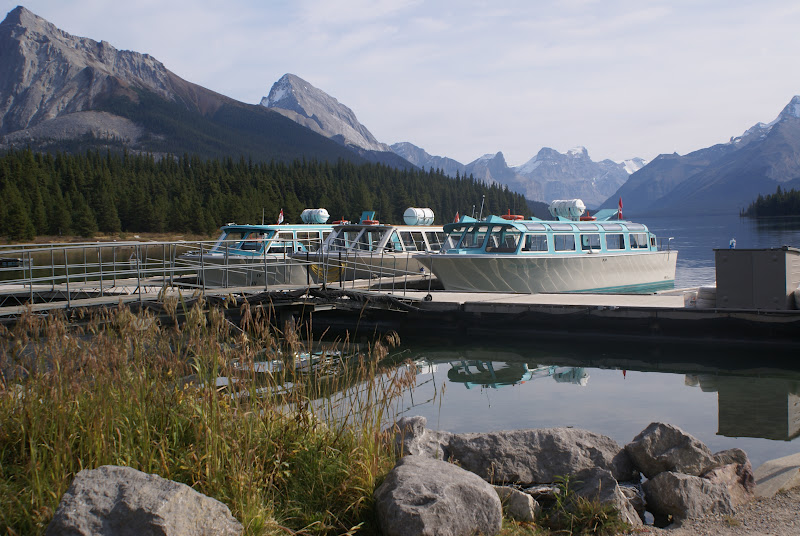
Maligne Lake.


We opted not to take the boat cruise.


The drive back into Jasper. This mountain is called the Endless Chain. I can see why. It looked like a movie backdrop. 


Tomorrow, we hit the road again. This time, we're heading back south and toward Montana via Roosville Border Crossing. 
In a few days we'll be at Glacier National Park.